PIERS AND STUFF
As the
Singapore based business and the Kalamazoo up-river traffic increased, more
commercial shipping developed on Lake Michigan. The Kalamazoo River mouth
area was the scene of most economic development in the early years, but by
1850 activity around Pier Cove began to grow – cordwood, sawed lumber,
tannery products, and farms sprang up. The story of the resulting shipping
business and the piers necessary for the areas success is an interesting
one.
The lack of a good harbor on the Lake Michigan shoreline presented an
impediment to the growth of business enterprise in the area. Though the
Kalamazoo River provided refuge from the open water of the lake, the
shifting sand bars and lack of piers presented problems for loading and
unloading vessels.
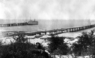
Unlikely as it now seems, open water piers solved the much of the problem.
The forces generated by lake waves and ice movement would seem to make these
rather crude structures impractical--and the construction method used to
build early piers is hard to imagine. Steam-driven pile drivers were not
available until the l860s so the very early piers were constructed using
levers, pulleys and brute manpower. But where there is a will-there is a way
and in the 1850s open water piers were constructed at Pier Cove,
Plummerville and Glenn. These piers-- rebuilt many times--remained in use at
Pier Cove until 1917.
In the early years when vessels were sail powered, if a sea was running,
loading at an open water pier was not possible. In calmer water in order to
load the schooners at the pier, the captain would drop anchor in deep water
and with the use of a long hawser and capstan, haul the vessel up to the
pier while at the same time, playing out the anchor line. When loading was
complete the process was reversed and the boat was drawn back into deep
water with the anchor line. If a weather threat appeared on the horizon, the
boat was quickly kedged back into safe water. A sharp eye was necessary
since a squall could wreak havoc with the boat and the pier.
There is evidence of an early breakwater-pier built of log cribs and sawmill
trimmings at the Kalamazoo River mouth. If the river mouth was blocked by
low water or sandbars the anchor line method of loading was used and in
addition cargo was transferred to smaller boats that could clear the bar.
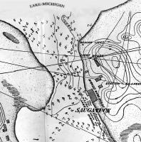
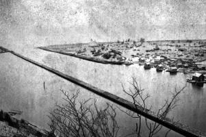
In 1873, construction was completed on sturdy north and south piers. The
construction consisted of oak pilings, 225’ apart, extending about 225’ to
310’ out from the shoreline. These were ballasted with stone and timbered
from the pier head all the way to Shrivers Bend on the southside and up to
the lighthouse on the north. The remnants of these piers are seen today.
Eventually, steam powered vessels, especially with the aid of tugboats, made
the whole loading process much easier.
By Jack Sheridan
|